
Day 28
2 miles of road walking getting back to trail
I got back to the trail after a chill morning, a scenic drive and a nice river stop. It was around 3 pm. Natalie and Sami took me right to where hikers can get back to trail after a portion that was closed due to some recent fire damage. Goldfish tagged along with our ride from LA but needed to go into Wrightwood for fuel and a new water filter so they dropped him off there.

I was a little hungover from the night before and the two beers I drank in the river and car sure didn’t help. I felt so sluggish. Before I started the 2 mile walk up a dirt road where you could rejoin the PCT, I laid down in the shade for a moment. I then walked 1.5 miles before needing to collapse in the shade on the road and took a little nap.

I eventually made it to Highway 2 which was closed in that area due to the fire damage. You could rejoin the PCT from here. With a big climb ahead of me, I decided I would just sleep there and then tackle it fresh in the morning.

I found a nice little hill to set up and went to use the pit toilets they had. When I came out I noticed a hiker crossing the street. I went to say hello. He introduced himself to me as Jacob and proceeded to pull out a 10 on bag of rolled oats from his tiny ultralight backpack. Explaining to me that he got it for free from a hiker box in Wrightwood. I laughed out loud in disbelief “and you don’t have a trail name” I laughed. He looked down with sullen anticipation of what he knew was coming “you’re Oats!” I exclaimed “there’s absolutely no way around this one” I feel like you’re forcing that upon he said with a smile, “yes absolutely, your choice if you introduce yourself to others like that but to me you will always be oats” I walked back to my little camp spot and did some journaling getting ready for bed.

Oats came up and asked if he could eat his dinner by me. You’ll never guess what he was having. Oats is a younger kid on a gap year of sorts he says as he graduated high school a couple years ago. He did more than 60% of the trail last year but with all the closures due to fires he wasn’t able to finish it. This year he started March 1st and has been going very slow and facing all the weather and not meeting many hikers, he said he was excited to talk with another hiker. He finished his oats and departed back to his campsite and I went soundly to sleep!
Day 29
Start: 374 End:390 + 3.2 reroute on a road
Total: 19.2
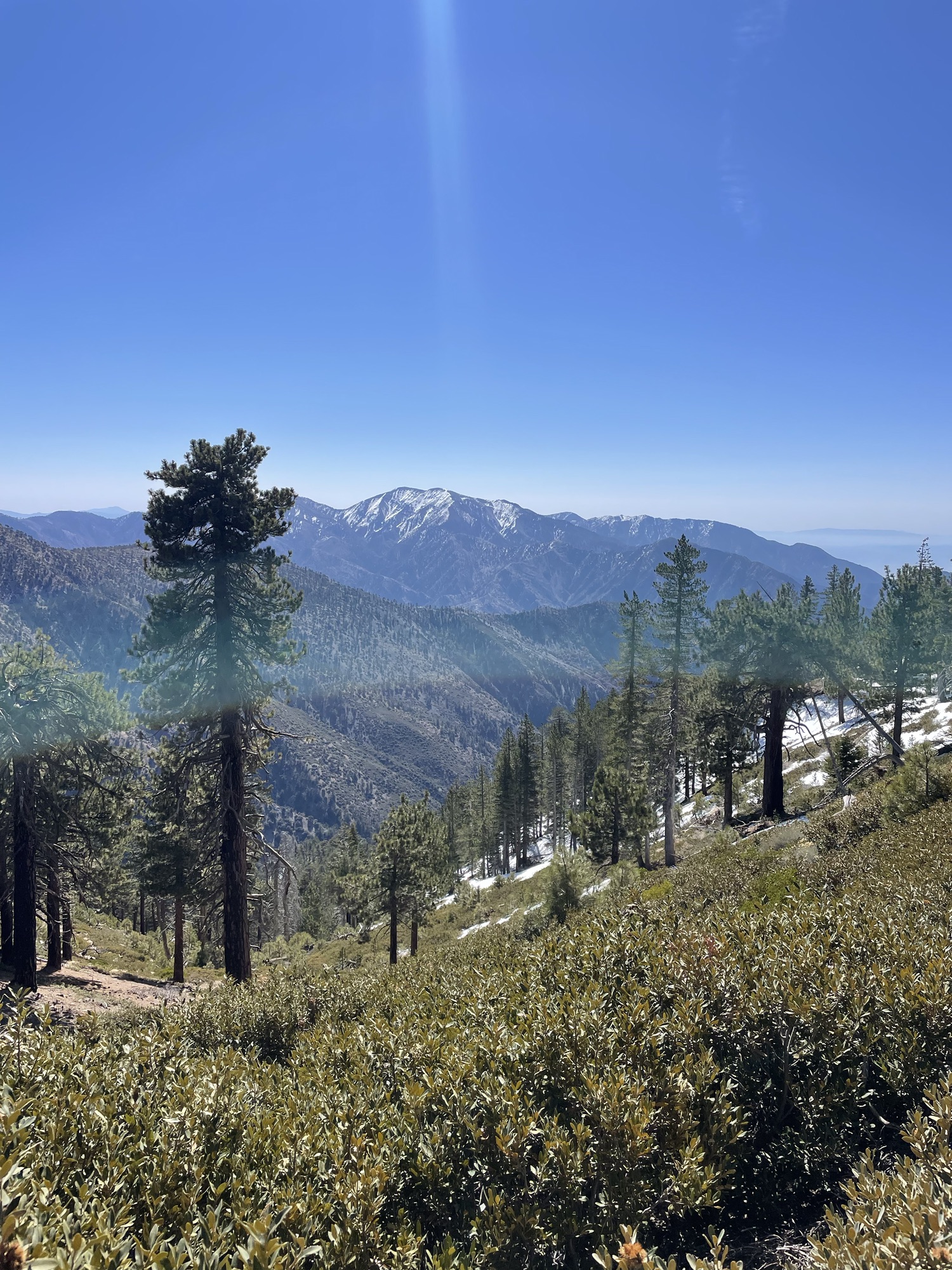
I awoke in the morning and had to drag myself out of the comfort of my sleeping bag. I had a big day ahead of me and would need an early start. You see the mountain I was about to climb, Mt. Baden Powell, still had a lot of snow, to where people were encouraging the use of spikes. But I had, like a big dummy, assumed the snow parts were done until the sierras, and sent my spikes and axe ahead to Kennedy Meadows. The start of the sierras. I was nervous for how I would do on this section and wanted to give myself all the advantages I could, which included going up early so the snow is still consolidated.

I began heading up the steep switchbacks, that would bring me 4000 feet higher in 4 short miles, around 6:15. I went up a couple steep snow free miles before getting water at a spring. After I continued upward, facing my first stretch of ice and snow, only 10 feet long but it was so icy and there were no foot holds for my feet to grasp. It must’ve taken me a couple minute to cross and I knew this was going to be tough. I kept going and there were sections here and there that still had snow until I got to apart of the trail that was covered. It was deep snow from here to the summit. Luckily someone had broke the trail before me and I had footsteps to follow in which made it much easier. I wasn’t post holing nor was I sliding around. It was fairly easy to just follow the footsteps.

At some points on track would follow the designated trail and switchback, but another set of footprints went straight up the mountain cutting the switchbacks. I followed each but then decided straight up the mountain would do. Following the footsteps to victory I soon made it up to the top. I was astonished to see that the summit was largely snow free. It was a beauotful view, one side the mountains, the other side the desert. This mountain was dedicated to Baden Powel who founded the Boy Scouts.


After safely getting to the top, I followed a mostly snow free ridge line along the spine of the mountain. A little ways away from the summit I came across Squirrel and Feather, a couple from Germany and Switzerland who had camped on the summit last night. I was envious for a minute thinking I could’ve made it up there but I knew it would’ve been slushier snow and I was not in the best hiking space the day before. I took my pack off and chatted with them for a bit before continuing on.

After I left that space the descent began and there were some snow covered parts. Lost in thought I didn’t have great footing and lost it, sliding down about 8 feet. I was okay besides a scraped finger and butt but it was a great wake up call that I needed to move mindfully and cautiously. I did a little more route finding on my way down, following a set of footprints into a bush then walking 50 feet through the bushes to where the trail supposedly was. I ran into a guy and asked him where he was going. “I’m not going anywhere I’m just trying to survive” he replied back. Soon after I ran into Steam who had trapped himself in between some fallen trees and live ones. I talked with him a bit then he crawled out of there and we hiked a bit together.

Steam did various corporate jobs for 18 years until becoming a teacher, he’s married, lives in Orange County and his son sells art in New York. We did the sketchier parts together, this is really where you would want microspikes. Steam had some but did not put them on because of how tedious it is to put on and take off and maybe to make me feel better at not having them. I was ahead and would slip and slide down a bit and then he would slide in the same spot, trying to make me feel better he said. There were some really sketchy parts that you would be in serious trouble if you slid down. Luckily every time I slid I caught myself soon enough on solid ground. I moved slowly with three points of contact and all my energies focused on each step. Steam stopped to put on microspikes and I kept going without much of a choice.

A couple miles later was Little Jimmy Canpground and I got some more water and took my shoes off and had a delicious lunch of summer sausage, cheese and avocado and a piece of lettuce. I took a long break hoping Steam would have made it in but he must’ve stopped before or taken a break. I kept going across a couple patches of snow, losing a lot of elevation and down until crossing highway 2. The trail crossed highway 2 and goes right back up, quite steeper than I am acustumed to on the PcT for 2 miles , peaks out with an incredible view. I sat down and ate a snack and and orange before going right back down, just as steep, crossing back over highway 2, which must’ve been .5 or 1 mile further down the road where I had crossed it the first time. It was a beautiful view up there but not an efficient use of energy in terms of traveling thousands of miles, it felt silly. I crossed highway 2 went up and down a couple more times before coming back on the road

There is an endangered frog species closure here that has been long standing. The trail has not been maintained for years. The suggested re route is a few miles of walking on the 2. I stopped at a picnic area and had a snack and soon enough Doc Holiday rolled in. He had spent the last two nights in Wrightwood and had started from Vincent gap around 9 am. We talked about how sketchy it was on the descent without microspikes and I told him about LA and he told me about Wrightwood. A group of hikers went to a Buffett one night and had some drinks. Then the next he sat in his hotel room and had a pizza and a beer. I told him that is my 0 day dream, to have a whole room and pizza and six pack to myself hah!

I hit the road and it was a chill 3 miles of walking although it is a windy road with not much shoulder and people go really fast so I had to be on high alert. I eventually made it to a campground where you cut through before making it back to the PCT. It’s still closed for the season but open to hikers so I planned on staying there the night.

On my way in to the campground a guy on a bike stopped to chat with me. I was so tired and ready to be done for the day but he was so excited and had so much energy I chatted with him for a couple minutes. Yes I am doing the PCT I told him, he had spent the day biking and fishing and adventuring on the trail nearby. He wished me luck and I was on my way.
I weaved through the campground and went to the final sites right before the trail that would lead me back to the PcT. The bathrooms were closed so I peed at my site and a second after getting my pants back up the biker speeds into my site. “I got back to my car and I thought she might be hungry she’s doing the PCT, I grabbed everything I had” this man says pulling out 8 granola bars from his pockets. I light up and graciously accept. He introduced himself to me as Keegan and we chat a little bit about the surrounding areas and he shows me some pictures of the sierras. Keegan is from Boston, his family is also from Michigan but he moved out here to be closer to the mountains. With a family at home a thru hike isn’t in the near picture but he was thrilled for me and I promised I would let him know what I think of the sierras! I thanked him again for all the snacks and he was off!

I set up and ate dinner then walked to the other end of camp to throw away some trash and find a better spot to filter water. Doc Holiday had made it in and set up on the further side of camp. I said hello before making my way back to my little cove and going to bed.


Day 30 Start 394 End 418.6 +1.6 reroute
Total=26.2
I once again struggled to get myself out of my sleeping bag but I did eventually and was walking by 7:30. I put my coffee and breakfast essential in my water bottle and had it on the go! It was a relaxing side trail to get back to the main PCT trail , I saw the waterfall that Keegan had told me about the day before but I just observed it from the trail and did not go down to it. It would have been an awesome break spot mid day but I was still a bit cold and wanted to keep moving.

After 1.6 miles and a huge tree to get over, I got back to the PCT and was welcomed back with a big climb. I got up and passed a campsite where there was a hiker but I kept going without stopping. I got up and over a ridge and it was a beautiful view within the highway two corridor and Los Angelous forest. I walked along the ridge before dipping back down, crossing the road a few times and having a couple steeper climbs before the trail evened out a bit. I crossed 400 miles at some point and popped out at a camp that is not in session at the moment. I walked a bit further then took a little break at a stream.

I listened to a podcast for 6 ish miles going through a very exposed and hot section. I stopped at a stream and aired the feet out and had lunch. I took a long break before making my way out of there. As I was approaching another side road I saw two guys in a forest fire truck driving along. I said hello and they stopped and we chatted for a bit. They were stationed at the millcreek fire station, 12 or so miles ahead. They introduced themselves as Jeremy and James and said they’d be there until 6 tonight or back at 9:30 in the morning. I told them I didn’t know where I was going to sleep, maybe I would push there tonight but that would be a long day. They asked me if I needed anything but I had plenty of water and only 5 miles until the next spring. I thanked them and they wished me luck!

I began the climb up the next mountain pass and regretted not getting more water at the stream I had lunch at because the heat was really starting to get to me and I was drinking a lot of water. After a steady climb upwards for 5 miles I got to the trickle of the stream and took my shoes and socks off once more and sat in the shade while I slowly gathered and filtered water. From there it was 8.6 miles to the fire station and only a couple more miles of climbing before it was all downhill.

My friend might be picking me up at a road on Sunday to take me to a highline so I needed to do 50 ish miles between this day and Sunday morning to be able to make it there. I hadn’t received confirmation yet but my faith was strong. This would allow me to have an easier day tomorrow and I could charge my power bank that takes overnight to fully charge.
After my water break I kept going upward and was rewarded with a panoramic view of the valley. I saw an awesome campsite but it was so windy and I would need to make more miles that day to get to the road where my friend would pick me up. I went up a little ways more before peaking out and had even better views of both of the valleys, where I had come from and where I was going. I went down following along the contours of the mountain and the ridge line. It was well shaded and beautiful pine forest. I popped out along a ridge and came to one more beautiful site right before the 3.8 mile descent into Millcreek fire station.

I took my pack off and debated staying there. It was such a beautiful site, the sunset would’ve been amazing and the sunrise would’ve been amazing. It was quite windy though. I weighed the pros and cons. I still didn’t know if I would need to push the miles and if my friend would be picking me up. But if I went further I could charge my stuff overnight and would have less of a day the next day. I felt in my gut that I should stick to my plan and that all would work so I continued on my way.
It was a breezy 3.8 miles down. It felt quite steep and I even jogged a bit on the way down. It was cool watching the sunset as I sped down the mountain.
I got to the fire station and no one was there so I just slept right behind the building!


Discover more from Trekking Home
Subscribe to get the latest posts sent to your email.